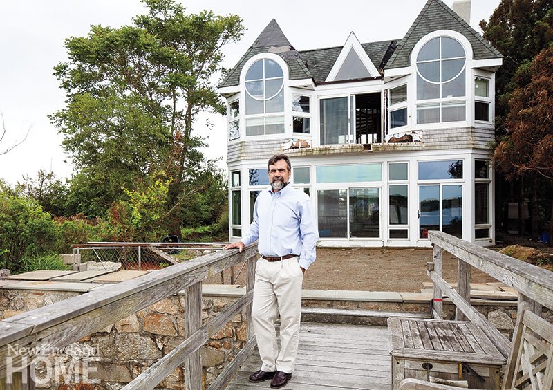
Architect Daniel Conlon on Rebuilding Connecticut Post Hurricane Sandy
July 16, 2013
Extreme weather over the past few years has been keeping this Georgetown-based architect very busy—and he sees plenty more work to come, for himself and for Connecticut’s homeowners.
Text by Kyle Hoepner Photography by Julie Bidwell
Kyle Hoepner: Perversely, the destruction caused last fall by Hurricane Sandy, and by Irene in 2011, has had a useful side for Connecticut architects and builders. Can you tell us a bit about that?
Daniel Conlon: Irene and Sandy brought sharp focus to the issues involved in coastal construction. In the short term, the damage caused by the storms has generated a lot of design and construction activity. While most of the media coverage of Superstorm Sandy focused on New York and New Jersey, parts of coastal Connecticut experienced widespread damage. Entire neighborhoods in several towns were left uninhabitable. The repair and replacement of those buildings has created a tremendous amount of work for architects, engineers and builders.
But in the longer term, the effects of new regulations for flood damage prevention will be much larger. The expansion of flood zones will require many more homeowners to purchase flood insurance and address flood compliance issues when altering their homes. Buildings will be stronger and safer, but they will be more costly, and we will be climbing more stairs to get into them.
KH: What are the regulatory changes, and what do they mean for homeowners?
DC: Coastal communities have adopted the most recent flood-zone maps issued by the Federal Emergency Management Agency (FEMA), which in most cases raise the minimum elevation at which habitable space can be occupied. This was the second revision to the maps in three years, and to make things even more confusing, the way the elevation is measured changed in 2010—so homeowners who have property surveys or flood certificates created before that date may discover that their home has a finished floor elevation a foot lower than what their survey says. Couple that with a higher base flood elevation, and a building built in full compliance with regulations as little as five years ago may now be three feet below current requirements. Also, many coastal towns have regulations that are more stringent than the FEMA standard: “FEMA plus one foot” isn’t uncommon.
Existing structures within flood zones don’t have to meet the new standard unless they are “substantially improved”—that is, unless the dollar value of renovation or repair amounts to more than 50 percent of the value of the existing structure, less any improvements to date. So owners of flood-damaged homes have to determine whether their cost of repairs will exceed that 50 percent threshold. If so, they must elevate the building or rebuild above the base flood elevation; if not, repairs can be made but the owner remains vulnerable to another storm—and since they have used up a chunk of their flexibility under the 50 percent rule, it is likely that the house will have to be lifted or replaced after the next big storm hits.
KH: That sounds complicated.
DC: The complications are just beginning. Once a decision is made to meet the flood regulations, owners have to decide whether to raise the structure or demolish and rebuild. This brings in another complex set of variables: What is the condition and construction quality of the existing home? Are the foundations adequate to support the lifted structure? If I tear it down, will the local zoning ordinances let me put it back in the same place? Is my property in a high wind zone requiring special structural design or impact glazing? How long will all of the required design and approvals take? Which agencies—ranging from the Army Corps of Engineers to the local planning board—have jurisdiction?
Even property owners who escaped damage from Sandy and Irene will face many of the same regulatory questions should they ever decide to renovate or rebuild.
KH: In design terms, what does this mean both practically and visually?
DC: The practical issues are fairly straightforward. Buildings and mechanical equipment need to meet minimum elevations, and in many cases to meet requirements for high wind zones. We go through the decision process outlined above, then look at specific construction requirements: Is there working space to lift the structure? What are the soil conditions and what type of foundation will be required? Will our excavations fill with water at high tide?
Then we determine if zoning variances are required in either height or coverage (the maximum area of a lot that can be built on). Coverage often comes into play because new, longer stairways are needed to access higher first floor elevations.
Aesthetically, for me, the key consideration is how the building meets the ground. In “A” flood zones, enclosed foundations are allowed when certain conditions are met. In more restrictive “V” flood zones, the building must be elevated on piers. This is more challenging, architecturally. How do we avoid the appearance of a house on stilts? How do we get into this building?
Another challenge is how to address the home’s relationship to neighboring properties. In the near term at least, formerly uniform streetscapes will be sprinkled with newly elevated buildings. It is important to be sensitive to this, because, barring a truly horrible disaster scenario, it is likely to take a generation before existing housing stock catches up with new design requirements.
KH: Do you have any preferred design solutions?
DC: In “V” zones, where we need to be significantly out of the ground, we like to employ masonry piers and arches instead of piles and wood beams, giving a much more grounded appearance to the building. Where appropriate, we capture the space below the building for outdoor living. In “A” zones, where nonstructural filling is allowed, we have used terraces to create an intermediate grade between the existing lot and the first floor.
KH: How are different cities and towns reacting?
DC: That, in my opinion, is the most interesting big-picture question of all.
Raising the base flood elevation vertically has a huge impact on the number of properties within a given flood zone. The new FEMA maps generally raise the base flood elevation by one to two feet. In some low-lying coastal areas a two-foot increase moves the zone boundary many hundreds of yards inland. This greatly increases the number of existing buildings within the flood zone, and especially the number of nonconforming structures. Homeowners whose properties formerly had no flood design requirements may suddenly find they have to partially fill in their basement, install flood vents and find a place for mechanical equipment on the first floor.
The number of properties that will be required to carry flood insurance in order to get financing will also increase dramatically. Flood insurance rates are rising sharply, and rates for conforming and nonconforming structures are different, so there will be motivation there for property owners to bring their buildings into compliance.
I think the cities and towns should be making accommodations for property owners to encourage compliance with flood regulations without violating other local ordinances. Westport’s Planning and Zoning Commission, for example, has adopted new regulations allowing buildings greater height and additional lot coverage when a structure is elevated to meet flood regulations. Other towns have amended zoning regulations allowing additional height for properties in flood zones, offered expedited approvals and waived permit fees.
One thing I’d love to see is a more streamlined process. We often have to present a project to several boards and commissions charged with review of specific elements of the project. It would be great if, in the case of an individual home, more of these approvals could be administrative, provided the project meets certain prescriptive criteria.
KH: Where do you see us headed from here?
DC: I see the picture becoming more and more complicated. So far I’ve focused most of my comments on coastal work, but flooding is also an inland issue. I’ve lived in southwest Connecticut all my life, and I see areas that never flooded years ago flooding now on a regular basis.
We seem to be having more frequent severe storms and there is little question that sea level is rising measurably. The Connecticut Department of Energy and Environmental Protection’s “Climate Change Primer” quotes numerous scientific sources predicting that today’s “100-year storms” are likely to happen every seventeen to thirty-two years, and that Connecticut sea levels will rise by a foot to a foot-and-a-half by 2100.
We’ll be required to design buildings capable of withstanding deeper water and higher winds. The challenge going forward will be to keep our design ideas fresh while complying with an increasingly complex matrix of applicable regulations
Share


You must be logged in to post a comment.